


FSWidgets QuickPlan

FSWidgets QuickPlan介绍
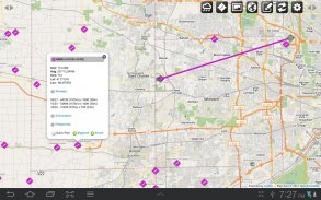
FSWidgets QuickPlan is a visual touch enabled flight planner that makes it easy to generate flight plans in native FSX, FS2004 or X-Plane formats.
For the folk commenting saying they didn't know it was a DEMO, we don't know how to make this any clearer. This is a DEMO only, the full version can be purchased from our site.
*** Please note, this is a DEMO VERSION ONLY ***
Demo is limited to the San Francisco (KSFO) region only, it is fully functional but will operate only in that region. For purchase details please visit our site and our store at <a href="https://www.google.com/url?q=https://www.google.com/url?q%3Dhttp://fswidgets.com%26sa%3DD%26usg%3DAFQjCNGAC5Ja3BdJ57QucRUliIl3x84tnA&sa=D&usg=AFQjCNHKGGS95vWeHmf62O3C8pxFtMQMQQ" target="_blank">http://fswidgets.com</a>. We provide this demo to give you the opportunity to test QuickPlan and ensure you are happy with its features. Should you decide to purchase, you will receive a key that will unlock the demo version.
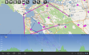
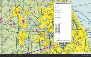
The entire route is generated visually, by tapping the map to add the departure airport, intermediate waypoints and arrival airport in the same order that you intend flying the plan.
Flight plans are saved and loaded using the SD card on the phone or tablet. Plans can be exported using any normal file browser on the Android device or by using standard Windows or Mac file management tools.
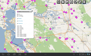
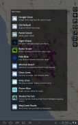
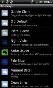
QuickPlan utilises a new mapping engine and includes 12 world-wide map styles and has support for FSWidgets Cloud Based Aero Chart products (free Cuba/Puerto Rico WAC Cloud Based Chart included) and the FSWidgets Cloud Based World Nav Data product (Free KSFO - San Francisco Bay area Nav Data included).
Main Features:
Supports tablets, hi-resolution phones, standard and low-end screens and devices
Generates native FSX (.pln), FS2004 (.pln) and X-Plane (.fms) format flight plans
Saves flight plans to the SD card, can be exported/imported
Flight plans can be exported via USB connection or SD card
Terrain profile display using the FSWidgets terrain engine
Search for airport by ICAO identifier
Map powered by CloudMade Leaflet API (using OpenStreetMap data)
Includes 14 world-wide maps styles
Supports FSWidgets Cloud Based Aero Charts
Free Cuba/Puerto Rico WAC Cloud Based Chart included
Supports FSWidgets Cloud Based World Nav Data
Free KSFO (San Francisco Bay) area Nav Data included
World-wide Metar and TAF Data icons
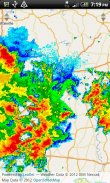
US Nexrad (Next-Gen Radar) Data
QuickPlan can be used in Freeform Mode, Advanced Mode, or a combination of both:
Freeform Mode:
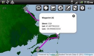
Simply tap anywhere on the map and QuickPlan will allow you to add it as a generic waypoint. VFR pilots often use towns, lakes and other unique geographic features and with QuickPlan you can add any geographical location shown on the base map. Plans created this way label the waypoints automatically with generic names (e.g. DEP, WP1, WP2, ARR).
If desired, the entire route from departure to arrival can be created without reference to any navigational aids or official airports. This is handy for bush pilots who often use unlicensed airfields and small landing strips (or seaplane landing areas). Helicopter pilots can also quickly create plans that depart from off-airport locations like building rooftops or land on a road.
Advanced Mode:
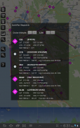
If you own the FSWidgets Cloud Based World Nav Data product you can create more advanced flight plans by tapping on any of the icons displayed on the map to add them as waypoints - airports, VOR's, NDB's and intersections (data for the KSFO area is included free). Plans created this way label the waypoints automatically with airport and navigational aid identifiers taken from the Nav Data (e.g. KSFO, OSI, LV, FABLA).
Who we are:
FSWidgets is a software development team based in Australia, specializing in add-ons for Microsoft Flight Simulator (Windows) and Laminar Research X-Plane (Windows, Mac, Linux). Both of its founding members have extensive experience in creating award-winning add-ons for flight simulators and have been active in the simming community for well over a decade.
</div> <div class="id-app-translated-desc" style="display:none">FSWidgets QuickPlan是一个可视化触摸功能的飞行规划,使得它容易产生原生FSX,FS2004或X-飞机格式飞行计划。
对于民间评论说,他们不知道这是一个DEMO,我们不知道如何使这个更清楚。这是一个DEMO而已,完整版可从我们的网站购买。
***请注意,这是一个DEMO版本只***
演示仅限于旧金山(KSFO)区域而已,它是全功能的,但将在该区域进行操作。对于购买详情,请访问我们的网站,我们的店在<a href="https://www.google.com/url?q=http://fswidgets.com&sa=D&usg=AFQjCNGAC5Ja3BdJ57QucRUliIl3x84tnA" target="_blank">http://fswidgets.com</a>。我们提供这个演示给你机会来测试QuickPlan,并确保您满意其功能。如果您决定购买,您将收到将解锁演示版的一个关键。
整条路线在视觉上产生,通过点击地图上添加出发机场,中间航点和抵达机场以相同的顺序,你打算飞行计划。
飞行计划被保存,使用SD卡的手机或平板电脑上加载。计划可以使用任何正常的文件浏览器在Android设备上或通过使用标准的Windows或Mac的文件管理工具导出。
QuickPlan采用了新的映射引擎,包括12个世界各地的地图风格和具有FSWidgets基于云的航空图的产品的支持(免费的基于古巴/波多黎各WAC云表附带)和FSWidgets基于云的世界导航数据产品(免费KSFO - 圣包括旧金山湾区导航数据)。
主要特点:
支持平板电脑,高分辨率的手机,标准和低端的屏幕和设备
生成本地FSX(PLN),FS2004(PLN)和X平面(FMS)格式的飞行计划
节省了飞行计划到SD卡,可以导出/导入
飞行计划可以通过USB连接或SD卡导出
使用FSWidgets地形引擎地形剖面显示
搜索机场国际民航组织标识符
地图(OpenStreetMap的使用数据)搭载CloudMade传单的API
包括14个世界各地的地图风格
支持FSWidgets基于云的航空图
包括基于自由古巴/波多黎各WAC云图
支持FSWidgets云为基础的世界净值数据
包括免费KSFO(旧金山湾区)区域导航数据
世界各地的METAR和TAF数据图标
美国新一代天气雷达(下一代雷达)数据
QuickPlan可以在自由形式模式,高级模式,或两者的组合来使用:
自由形式模式:
只要点选地图上任何地方,QuickPlan将允许您添加它作为一种通用的航点。 VFR飞行员经常使用的城镇,湖泊等独特的地理特征,并与QuickPlan您可以添加底图上显示的任何地理位置。计划建立的这种方式与通用名称(如DEP,WP1,WP2,ARR)自动标记航点。
如果需要,可以在不参考任何助航设备或机场正式建立从出发了整个路线的到来。这是非常方便的丛林飞行员谁经常使用无牌机场和小型飞机跑道(或水上飞机降落区)。直升机飞行员还可以快速创建从机场外位置的建筑物屋顶或土地在道路上离开的计划。
高级模式:
如果您拥有FSWidgets基于云的世界NAV数据产品,您可以通过点击任何显示在地图上添加它们作为航点图标创建更高级的飞行计划 - 有关机场,VOR,NDB的和交叉点(数据为KSFO区域包含免费的)。计划用这种方式创建从导航数据采取机场助航设备标识符(如KSFO,OSI,LV,FABLA)自动标记航点。
我们是谁:
FSWidgets是一家总部设在澳大利亚的软件开发团队,专注于附加组件微软飞行模拟器(Windows)及层流研究X飞机(在Windows,Mac,Linux)的。两个创始成员在创造获奖的附加程序飞行模拟器丰富的经验,并已在simming社区活跃了超过十年。</div> <div class="show-more-end">
FSWidgets QuickPlan - 版本2.2 - Jan 24, 2015
(08-02-2015)
FSWidgets QuickPlan - APK信息
APK版本: 2.2 - Jan 24, 2015程序包: com.fswidgets.quickplanFSWidgets QuickPlan的最新版本
其他版本


同类应用
您可能还会喜欢……
 4.144.184.384.414.44


